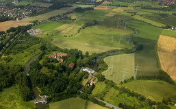
Measure block Westenmersch
This measure block is localized between “Haus Uentrop“ and “Zechenbahntrasse“ which connects the townships of Hamm and Dolberg. A major part of the project area is situated in the southern part of the Lippe, i. e. on the left side of the flow direction. Currently, the actions in the measure block Westenmersch have not been introduced yet. You are also invited to have a look at information on the other measure blocks which you can find on the left hand side of this page.
The following actions are planned to be taken soon in the section Westenmersch:
1. Removal of Bank Reinforcement
Unleashing, which means removing bank reinforcement of the Lippe by means of enrockments, is affected over a distance of several hundred metres. This demolition action is carried out to recreate its natural dynamics and to give it back its freedom to move. As a positive consequence of this unleashing measure, steep banks and shallow water zones will develop over the course of time, which are - contrary to the yet uniform embankments – very rich-textured habitats.
2. Creation and Optimization of Floodplain Basins
Floodplain basins are natural sinks rich in structure and species and link the floodplain – river system in times of high water levels. In the last centuries, however, floodplain basins were often filled and levelled for a better use of agricultural areas. That is why today they are difficult to recognize. Many times they can only be identified by the help of historical maps. As floodplain basins have an impact on the water balance of a river and its floodplain, they are of major importance as a habitat for many species like certain water birds (also see: Floodplain habitats). Therefore, we are planning to create a “new” floodplain basin in the southern section of this block which will end in a dyke named Munnebach. Additionally, there is a plan to reconnect a former river arm in Westenmersch with the Lippe by creating a flood channel so that an exchange between river and back water becomes possible.
3. Creation of Standing Water Bodies and Shallow Ponds
Standing water bodies are a part of formerly natural floodplains and serve many varied amphibians, dragonflies, fish and birds as a vital habitat (also see: Floodplain habitats). Standing water bodies are much deeper than shallow ponds and are therefore protected against drying. This means that they bear water year-round and offer an ideal habitat to the so-called “still water species”, i. e. species which do not like streaming. As small ponds fall dry periodically, they are not a habitat for fish but especially for small animals like amphibians and nymphs enjoying the safety of this habitat. In the past, many standing water bodies and small ponds were also affected by the agricultural, economic utilization of land due to fillings and drainage. Many ecologically important habitats were lost by these actions. In the measure block Westenmersch we are planning to install two standing water bodies and two shallow ponds. Furthermore, we will most likely create a tranquil back water zone connected to the Lippe.
4. Re-water Logging and Development of Marsh Land
Grassland areas used to be wet in the floodplains and were often submerged for many weeks especially in the winter season. From time to time, the floodplain meadows changed into water bodies of wide extension and were an attractive habitation particularly for water birds as well as for frogs, efts and other amphibians. Marsh lands are often areas where big cane brakes develop, which are attractive breeding grounds with rich food supply for dragonflies and reed liking bird species like reed warblers, the trademark of our projects LIFE and LIFE+. The extension and accumulation of existing drainage ditches is intended to attribute to re-water logging of meadows and grazing lands in the northern part of the measure block Westenmersch. All in all, ground level re-water logging measures in the measure block Westenmersch are planned to cover an area of 8.8 ha.
5. Extensive Agricultural Utilization of Land
This means gentle pasturing of grassland or its use for swathe. An extensive utilization of agricultural areas is planned within the whole measure block Westenmersch. Especially wet meadows and areas without trees offer a vital habitat to many birds breeding at ground level. An extensive way of pasturing grassland is to keep ungulates. This measure keeps the areas free of high vegetation cover.
6. Development of Alluvial Forest
Even in a natural floodplain there are tree populations which are called alluvial forests (please also see: Floodplain habitats). This kind of forest mainly differs from other forests in the way it is used to the influence of river water. Floodplain trees fairly manage living in flood water over a long period of time. Depending on the duration of the flooding of a forest, soft and hard wood alluvial forests are differed. Some typical tree species you can find in hard wood alluvial forests are forest oaks, ash trees, maples, elm trees and black cherries. Also, there are typical shrubs like whitethorns, blackthorns, red cornels, spindle trees, hazelnuts or common guilder roses. In the past, man did his best to clear this alluvial forest in the floodplain of the Lippe to replace it by meadows and areas of arable land. This is why today there is only a small share of alluvial forests in the project area. Now the plan is to create a new, large hard wood alluvial forest in the measure block Westenmersch. To accelerate the process of natural development (succession), typical tree species are planted on a stipulated part of the area. These carefully chosen and planted species are supposed to multiply independently and to found a new alluvial forest within a period of some decades.

