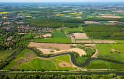
Measure block Schlagmersch
The measure block Schlagmersch is the westernmost section of the project LIFE+ and is situated near to the castle of Heessen. Currently, actions have not been taken yet in the measure block Schlagmersch but in this section the most spectacular building measure of LIFE+ is planned: upraising of the river bed.
The following actions are planned to be taken soon in the section Schlagmersch:
1. Upraising of the River Bed
In the 1960s, the banks of the Lippe were stabilized by stone rip-rap packing. Originally the purpose of this measure was the interest of safety in case of high water which was supposed to be diverted faster this way. Furthermore, the mobility of the Lippe was restrained, so that the Lippe could not build new oxbow lakes.
In the last decades, however, it became more and more obvious that the Lippe developed a deeper river bed due to its reinforced banks. Now some sections are several metres deeper in comparison to river bed sections of natural flow. This sinking process (also known as bed erosion) has negative consequences. For example, ecologically precious floodplain habitats were severely reduced because Lippe broke its banks only once in a few years.
The countermeasure now is not only to remove bank reinforcements along many sections of the Lippe (please also see the other measure blocks) but to counteract bank erosion. In the measure block Schlagmersch we are planning to conduct an upraising of the river bed over a distance of 1.1 kilometres to raise it to its original level.
2. River Course Extension
Over the course of the Lippe conversion, the actions were not only to reinforce river banks but to go through oxbow lakes in order to create a straightened river for improved shipping conditions. Thereby, Lippe’s river course was shortened while its flow velocity was increased at the same time. In the western part of Schlagmersch the creation of two new oxbows is planned. Its consequence forms a shape like an “S”. This course extension will reduce the flow velocity of the Lippe as well as its erosion capacity. In connection with the upraising of the river bed Lippe is enabled to regain its original course in the measure block Schlagmersch.
3. Creation and Optimization of Floodplain Basins
Floodplain basins are natural sinks rich in structure and species and link the floodplain – river system in times of high water levels. In the last centuries, however, floodplain basins were often filled and levelled for a better use of agricultural areas. That is why today they are difficult to recognize and many times they can only be identified by the help of historical maps. As floodplain basins have an impact on the water balance of a river and its floodplain, they are of major importance as a habitat for many species like certain water birds (please also see: Floodplain habitats) which is why the creation of a “new” floodplain basin is planned in the measure block Schlagmersch as well as in the other sections. In the north, i. e. on the right hand side of the flowing direction, this floodplain basin will connect the Lippe with a former oxbow lake.
4. Converting Areas of Arable Lands to Grassland and Cultivating Close to Nature
In the measure block Schlagmersch a majority of areas is planned to be used agriculturally in a nature friendly way on both sides of the river. In doing so, grassed areas are either carefully used as pastures or as mowing areas. Especially wet meadows and areas without trees offer a vital habitat to many birds breeding at ground level. An extensive way of pasturing grassland is to keep ungulates. This measure keeps the areas free of high vegetation cover. Within the framework of the project LIFE+ the yet outstanding agricultural area is planned to be converted to grassland.
5. Development and Optimization of Alluvial Forest
Even in a natural floodplain there are tree populations which are called alluvial forests (also see floodplain habitats). This kind of forest mainly differs from other forests in the way it is used to the influence of river water. Floodplain trees fairly manage living in flood water over a long period of time. Depending on the duration of the flooding of a forest, soft and hard wood alluvial forests are differed. Some typical tree species you can find in hard wood alluvial forests are forest oaks, ash trees, maples, elm trees and black cherries. Also, there are typical shrubs like whitethorns, blackthorns, red cornels, spindle trees, hazelnuts or common guilder roses. In the past, man did best to clear this alluvial forest in the floodplains of the Lippe to replace it by meadows and areas of arable land. This is why today there is only a small share of alluvial forests in the project area. In the measure block Schlagmersch, in the south of the Lippe, first plantings of typical species of alluvial forests have been conducted long time before the beginning of the project LIFE+. Now, this stock of trees is to be optimized and extended by linking it to the water regime of the Lippe.

