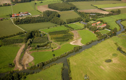
Measure block Mühlenlaar
The measure block Mühlenlaar is related to areas situated in the north of the castle “Schloss Oberwerries”. This measure block is the smallest section of our project LIFE+ and it is situated very close to measure block C of the previous project LIFE which has an information path called Lippeauen-Pfad.
In fall 2011, the action in measure block Mühlenlaar and thus the first were implemented in the current LIFE + project.
Here you can learn about in detail the measures implemented:
If you like to know more about the other three measure blocks, please have a look at the left side of this page.
The actions planned for realization in the measure block Mühlenlaar are the following:
1. River Bank Renaturation
In the eastern part of the measure block the right side of the Lippe bank was “uncorset”. This means that Lippe’s banks once were stabilized by stone rip-rap packing which are now removed. This restoration measure is conducted to regain the mobility and natural dynamics of the river. As a positive consequence of the removal of the stone corset it is very likely that bluffs will develop in the course of time. These bluffs are attractive hatcheries for species like sand martins and kingfishers. By the way: the river banks of the left side of the Lippe have already been “uncorseted”.
2. Creation and Optimization of Floodplain Basins
Floodplain basins are natural sinks rich in structure and species and link the floodplain – river system in times of high water levels. In the last centuries, however, floodplain basins were often filled and levelled for a better use of agricultural areas. That is why today they are difficult to recognize and many times they can only be identified by the help of historical maps. As floodplain basins have an impact on the water balance of a river and its floodplain, they are of major importance as a habitat for many species like certain water birds (please also see: Floodplain habitats). Therefore, a “new” floodplain basin in the measure block Mühlenlaar was created. In future, this floodplain basin is supposed to link the Lippe with a former pond named Mühlenteich in the east of the castle “Schloss Oberwerries” in times of high water levels. Additionally, the ditch Westhusen (Westhusener Bach) was widened and also reconstruct it as a floodplain basin.
3. Extensive Agricultural Utilization of Land
As planned in the remaining three measure blocks, in the measure block Mühlenlaar, an extensive agricultural utilization was implemented. In doing so, grassed areas are either carefully used as pastures or as mowing areas. Especially wet meadows and areas without trees offer a vital habitat to many birds breeding at ground level. An extensive way of pasturing grassland is to keep ungulates. This measure keeps the areas free of high vegetation cover.
4. Development and Optimization of Alluvial Forest
Even in a natural floodplain there are tree populations which are called alluvial forests (please also see: Floodplain habitats). This kind of forest mainly differs from other forests in the way it is used to the influence of river water. Floodplain trees fairly manage living in flood water over a long period of time. Depending on the duration of the flooding of a forest, soft and hard wood alluvial forests are differed. Some typical tree species you can find in hard wood alluvial forests are forest oaks, ash trees, maples, elm trees and black cherries. Also, there are typical shrubs like whitethorns, blackthorns, red cornels, spindle trees, hazelnuts or common guilder roses. In the past, man did best to clear this alluvial forest in the floodplain of the Lippe to replace it by meadows and areas of arable land. This is why today there is only a small share of alluvial forests in the project area.
In this section, first plantings of typical species of alluvial forests have been conducted long time before the beginning of the project LIFE+. Now, this stock of trees has been optimized and extended by linking it to the water regime of the Lippe. In collaboration with the Lehr- und Versuchsforstamt Arnsberger Wald (Teaching and Experimental Forestry Office Arnsberg Forest) and the Zukunftsfabrik Hamm in the project an almost vanished species of our floodplain was replanted - the black poplar (Populus nigra).
5. Visitor Direction
In a nature protection area, human beings are often disruptive elements for many sensitive animal and plant species without even knowing it. Targeted visitor direction is of major importance to make the FFH area “Lippeaue between Hangfort and Hamm”, with its species keenly worth protecting, accessible to all citizens. Near the castle, a crossing is planned in the form of a ferry which is to be driven by muscular strength. This ferry offers space for carrying bicycles on board. The ferry went on stream on 25th of April 2013.

